Taunus Hike
Day 6: Obernhof to Bad Ems
7/7/01, 10:13; Nassau, Very nice path from Obernhof along the Lahn. Just past Obernhof you pass by the Kloster Anstein up high, then there is a paved, fairly narrow path along the river to Nassau.
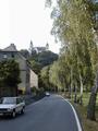
Leaving Obernhof & looking back at Arnstein - Trail to Nassau
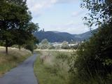
Nassau is a much bigger place than Obernhof. There are places to stay where the trail meets the road, just outside of town (also a Weinstube with an amazing grapevine-covered balcony) . I came into town to cash travelers checks and get some drinks. Not sure what made me think a German bank would be open on a Saturday! There's a bank and grocery store right next to the fountain in the middle of downtown. Nassau is also on the Lahn, there is a very large campground on the river. It rained last night, it's partly cloudy now.


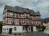
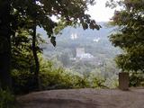
Approaching Nassau (Burg Nassau up high) - Town center - Rathaus
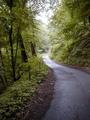
4:05, Bad Ems. Got here around 2:00 but not how I expected to arrive, namely by train. From Nassau, the E1 trail heads up north and I want to keep going west, towards the Rhein. So I decided to take today and tomorrow the Lahn "Höhenweg" (high trail) which ends in Lahnstein, on the Lahn and Rhein rivers. Actaully, that trail merged with the E1 yesterday. The marking for this trail is a black L on a white background. On the north side of the Lahn, there is another Lahn trail, marked with a white L on a black background. The trail this morning out of Nassau was very easy to find. It was also very smooth, and fairly level, so I was cruising at a good clip. Also not bothering to check my map since I saw lots of L signs. After a while the trail crossed a small footbridge and started a long ascent. Eventually, after 3 or 4 km, the trail passed a huge landfill. I realized I hadn't seen any L markers for a while, but hadn't worried because there were no intersections or side trails. But all of a sudden, the trail came to a fork - with 3 possible directions and no signs! The map provided no help. I decided to climb a fire tower I saw down one of the paths, to see if I could get my bearings. Only thing I could see was a highway not too far away. So I decided to hike to the highway and find out where I was. Turns out I was near Singhofen, a town about 6 km southeast of Nassau - and I had thought I was 8-10 km west of Nassau! By this time it was almost 1:00. I decided to eat my lunch, then try to hitch a ride back to Nassau. After a few minutes a guy stopped and drove me back to Nassau. So at 1:15 I was at the fountain, downtown Nassau, where I had been at 10:30! At that point-given the rain clouds-I packed it in for the day and took the train to Bad Ems (3DM).
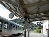
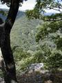
Admitting defeat - Trail while lost
Bad Ems is a resort town ("Kurort") with mineral water bathing as its main attraction. There are huge, very expensive looking hotels. I passed them by and found a modest place on a side street towards the business district, and away from the baths. It's the Pfälzer Weinstube - 40 DM with breakfast. Since it's raining, I decided to eat in. I bought 2 rolls, soup mix, beer and a chocolate bar at the "Penny Markt" (4DM) . I brought an immersion water heater, which I'll now finally get a chance to use.
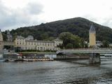


Bad Ems: Kurhotel - Kurhaus - Casino
Total: 16 km (?)


rgjones@vcu.edu